


PPM Commander - GPS status

Description de PPM Commander - GPS status
Connect your external GPS device by USB or bluetooth. Route the GPS position as mock location provider to any navigation app on your phone or tablet.
Show GPS status data like position, height, accuracy, satellites, velocity, etc.
You can forward RTK correction data to your high accuracy external device. RTCM data is loaded from the internet by the internal NTRIP client.
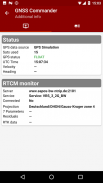
The app ist completely free with the exception of the NTRIP-RTCM feature. If you want to forward RTK data from your data provider (e.g. land surveying office) to the external GPS antenna, please license the app. You can fully test the NTRIP feature in advance within the 30 days trial period. You can view received RTCM message-types and coordinate-projection-parameters of the RTK data on the RTCM monitor page.
PPM Commander supports devices from ppm GmbH only, eg. ppm-10xx!
The PPM Commander can transform WGS84 coordinates into a local coordinate system like "Gauß-Krueger or UTM" for germany. Additionally you can set a fixed offset to the transformation for further improvement of the calculated local coordinate. If you allow mock locations in the developer options of your android device you can use the position of the external receiver in any application. The preferred way to process the external GPS position in other apps without using "mock locations" is implementing a simple ContentObserver. You can even get the transformed local coordinate and additional informations about the GPS status by using the app as content-provider.
By activating the "mocking" feature (get the position of your external GPS antenna into android) you can use this app for any other navigation-app or for geo-tagging.
Free features
+ GPS Status
+ Satellite list & Sky-Plot with subsystems like GPS, Glonass or Galileo
+ Coordinate-Transformation into local coordinate system
+ Mock location provider (e.g. use your external device for navigation)
+ Log all received NMEA data
You need a license for
+ RTK correction data over internet (NTRIP client)
+ RTCM monitor
+ Android "content provider" feature to access all status data
Connectez votre périphérique GPS externe à l'aide de USB ou Bluetooth . Acheminez la position GPS en tant que fournisseur de localisation fictive vers n'importe quelle application de navigation sur votre téléphone ou votre tablette.
Affichez les données d'état GPS telles que la position, la hauteur, la précision, les satellites, la vitesse, etc.
Vous pouvez transférer les données de correction RTK vers votre périphérique externe haute précision. Les données RTCM sont chargées à partir d'Internet par le client NTRIP interne.
L'application est totalement gratuite, à l'exception de la fonctionnalité NTRIP-RTCM. Si vous souhaitez transférer les données RTK de votre fournisseur de données (par exemple, un bureau d'arpentage) à l'antenne GPS externe, veuillez autoriser l'application. Vous pouvez tester complètement la fonctionnalité NTRIP à l’avance au cours de la période d’essai de 30 jours. Vous pouvez afficher les types de message RTCM reçus et les paramètres de projection de coordonnées des données RTK sur la page de moniteur RTCM.
PPM Commander prend en charge les appareils de ppm GmbH uniquement, par exemple. ppm-10xx!
Le commandant PPM peut transformer les coordonnées WGS84 en un système de coordonnées local tel que "Gauß-Krueger ou UTM" pour l'Allemagne. De plus, vous pouvez définir un décalage fixe pour la transformation afin d'améliorer encore les coordonnées locales calculées. Si vous autorisez des emplacements factices dans les options de développement de votre appareil Android, vous pouvez utiliser la position du récepteur externe dans n’importe quelle application. La méthode privilégiée pour traiter la position GPS externe dans d'autres applications sans utiliser les "emplacements fictifs" consiste à mettre en œuvre un simple ContentObserver. Vous pouvez même obtenir les coordonnées locales transformées et des informations supplémentaires sur l'état du GPS en utilisant l'application en tant que fournisseur de contenu.
En activant la fonction "moqueuse" (obtenez la position de votre antenne GPS externe dans Android), vous pouvez utiliser cette application pour toute autre application de navigation ou pour le géolocalisation.
Fonctionnalités gratuites
+ Statut GPS
+ Liste de satellites et Sky-Plot avec des sous-systèmes tels que GPS, Glonass ou Galileo
+ Transformation de coordonnées en système de coordonnées local
+ Fournisseur de localisation fictif (par exemple, utilisez votre appareil externe pour la navigation)
+ Enregistrer toutes les données NMEA reçues
Vous avez besoin d'une licence pour
+ Données de correction RTK sur Internet (client NTRIP)
+ Moniteur RTCM
+ Android "fournisseur de contenu" fonctionnalité pour accéder à toutes les données d'état
PPM Commander - GPS status - Version 2.8.2.3
(13-06-2021)
PPM Commander - GPS status - Information APK
Version APK: 2.8.2.3Package: de.pilablu.gnsscommanderAncienne Version de PPM Commander - GPS status
Autres versions


Applications de même catégorie

Vous pourriez également aimer...


